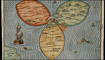
Norman B. Leventhal's map collection includes this one of the world by Heinrich Bünting from 1581. (Courtesy of the Norman B. Leventhal Map Center at the BPL)
The Boston Globe
Maps lead to a public jewel
Donor's $10m gift lets library display priceless collection
By Thomas C. Palmer Jr., Globe Staff | September 6, 2007
Retired Boston developer and map aficionado Norman B. Leventhal is contributing $10 million for a permanent endowment of the Boston Public Library's map center, the library's largest gift ever.
In an announcement to be made at the library today, Leventhal, who built a significant piece of Boston's skyline and who last week turned 90, is also making a long-term loan to the Norman B. Leventhal Map Center of 178 of his most valuable historic maps of Boston, New England, and the world.
Leventhal and library executives created the center, now in several rooms open to the public only by appointment, about three years ago.
The 178 maps he is donating - about half of Leventhal's collection since he purchased his first map of Boston in London in the early 1970s - will join 200,000 maps already at the library. All of them, both originals and reproductions, will be used increasingly in an educational outreach program for students in Massachusetts and the rest of the nation, funded by the Leventhal gift, library officials said yesterday.
"Maps certainly fascinate me. They're a great educational tool," Leventhal said. "You can learn about geography, history, a lot of things. They're pieces of art."
Among the 400-piece Leventhal collection: John Seller's "A Mapp of New England," from London in 1675, was the first large detailed map of the region. A map published in Paris, "Plan de la Ville et du Port de Boston," is from 1764 and shows early Boston, the little Shawmut Peninsula, almost cut off from the mainland. "Map of the city of Boston and vicinity" is a 1908 lithograph, in pale pink, yellow, and green.
The larger map and atlas collection at the BPL's Leventhal Map Center includes historically significant depictions of the United States, Europe, and the world. The entire collection will be further restored and preserved through a nonprofit corporation funded by Leventhal's gift.
Leventhal's maps are a priceless collection of depictions of the world dating back to 1486, documenting the discovery of the New World and following the development of Boston and New England into the 20th century.
The maps are being digitized and put on line - about 800 are already available - and that effort will now be accelerated, Boston Public Library executives said. In a couple of years or so, a permanent space will be created for the map center in the library's original McKim building at the main branch on Boylston Street.